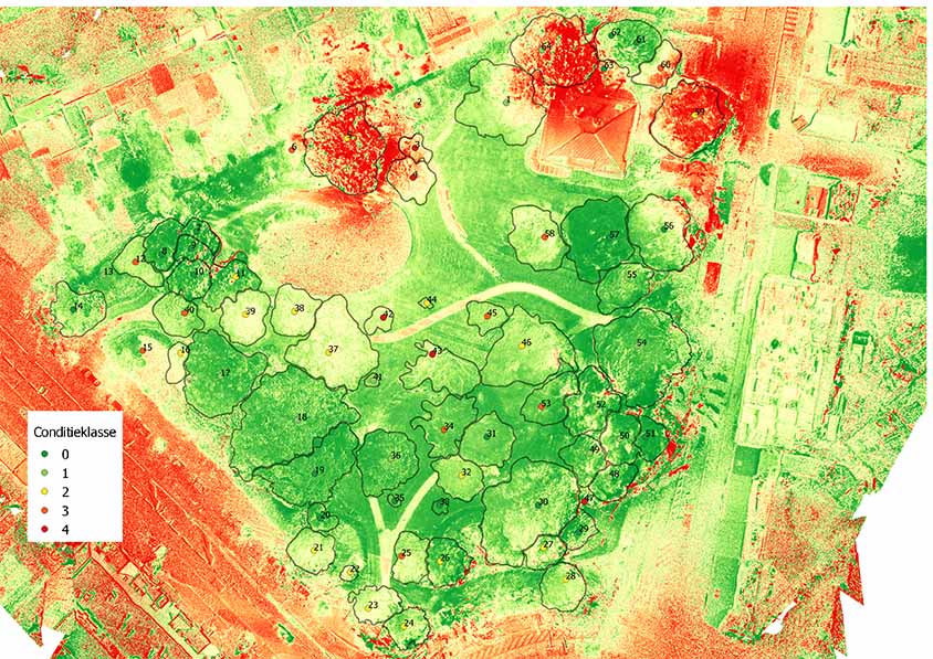
Health monitoring urban trees
By using satellite data from the Copernicus project Sentinel 2 which has an infrared sensor, we are trying to assess the health of the urban trees by using time series analysis. Since infrared imagery is …
Today, the maximum yield from urban forests ecosystem services has not been sufficiently structured. One of the biggest stumbling blocks is the lack of an (up to date) inventory as this is time consuming and seldom area covering. Advances in remote sensing and image processing allow us to view urban green spaces at city level …
Manual surveying the urban forest is a time consuming and monotonous task with the risk of being outdated from the moment you start. The lab has worked out a workflow based on lidar and multispectral data from aerial imagery to detect tree crowns. This allows us to calculate the percentage of tree crown cover, segmenting …
i-Tree is de referentie in het kwantificeren van de waarde van het stedelijk bos. Het werd in 2006 ontwikkeld in de Verenigde Staten en wordt op vandaag steeds populairder in Nederland en Vlaanderen. Het programma berekent in detail de ecosysteemdiensten van het bos zoals waterbuffering en verkoeling (in euro’s). Ecosysteemdiensten zijn diensten die het ecosysteem – hier …
VIVES looks at how to use drone technology as a complementary tool in a detailed tree survey. Drones are still too often considered gadgets. Yet, we see them increasingly making their appearance in various sectors such as emergency services, construction, plant inspection…. We want to see if the drone offers technical and financial added value for …
Remote sensing (of teledetectie) in urban forestry is de techniek om, vanop afstand, informatie te verkrijgen van het stedelijke bos. We hebben het dan over satellietbeelden, luchtfoto’s, dronebeelden… Door gebruik te maken van multispectrale beelden ontwikkelen we een tool om via quickscans de boombeheerder bij te staan in het lokaliseren van de probleemgevallen binnen het stedelijk bos. Hiervoor gebruiken we infrarood- beelden van vliegtuigen en drones. Op …
Conditiebepaling van bomen via remote sensing (drones) Read More »